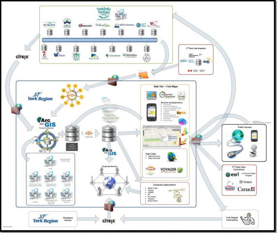
The Regional Municipality of York’s Enterprise Geographic Information System (GIS) program has won the 2015 Urban and Regional Information Systems Association (URISA) Exemplary System in Government award. The award is considered the most prestigious recognition available in the field of GIS, presented to organizations that use GIS to improve the world and set new precedents throughout the GIS community.
The Region’s submission illustrates the innovative approaches being taken to enable partners, citizens and staff to access and use information quickly and efficiently, leveraging data, analytics, and mapping for municipal services, including water and wastewater.
The submission outlines how the Region’s focus on data, partnerships, capacity building and ease of use have led to remarkable results.
“This award recognizes York Region’s commitment to providing timely services to residents and business,” said York Region Chairman and CEO Wayne Emmerson. “Our stakeholders are better informed and we are responding through a one-window approach to their information needs.”
York Region leverages data, analytics and mapping in many ways—from supporting improved water and wastewater planning and operations to the delivery of paramedic services across the Region.
“In the past, our water/wastewater information often was difficult to share. We each maintained our own databases and the data had various standards, accuracy and completeness,” said Bill Chihata, Program Manager of Water Conservation & Efficiency for York Region.
“We began a project with the Region’s GIS branch to create a basic set of data standards and an information system that we could all use to maintain a common picture of what’s underground. Now, everyone knows what pipes are where and who’s responsible for them; and it’s mobile too, so our field workers can be on-site getting immediate feedback and working more effectively,” he said.
“Staff have engaged, listened and created a corporate solution that helps the Region understand and meet the expectations of stakeholders and residents,” said York Region Chief Administrative Officer Bruce Macgregor.
Much of the Region’s Enterprise GIS can be accessed publicly through YorkMaps.ca
URISA is a non-profit association whose members work in local, regional, state/provincial, tribal and federal government, academia, the private sector and non-profit organizations.