After wildfire, the devastation to the landscape and communities is obvious and unforgettable.
And now, a UBC Okanagan researcher is taking a different look at fire-impacted areas. Dr. Alessandro Ielpi, an Assistant Professor in Geomorphology with UBCO’s Irving K. Barber Faculty of Science, recently published research examining how the record-setting 2017 Elephant Hill Fire affected the Bonaparte River near Cache Creek, BC.
The research was recently published in CATENA, and was developed in collaboration with his colleague and long-time friend Mathieu Lapôtre, an Assistant Professor in Earth and Planetary Sciences at Stanford University.
The wildfire started in July 2017 southwest of Ashcroft, rapidly growing northward. It eventually burned 192,000 hectares and destroyed more than 100 homes in two months.
“It takes a few years to gain a full picture of how a wildfire has impacted a river. It’s sort of like a fog of war slowly lifting,” says Dr. Ielpi. “The Bonaparte River’s watershed was significantly impacted by the Elephant Hill Fire—about half of the entire watershed was burned to some degree.”
Dr. Ielpi says it’s important to keep in mind the Bonaparte—with a watershed shy of 4,000 square kilometres in surface area—is not a huge river system compared to, say, the Fraser, Mackenzie or Yukon rivers.
“When you think of a wildfire that impacts 1,900 square kilometres, it is indeed enormous. But watersheds are typically much larger,” he explains. “If you look at the watershed of very large rivers, they are hundreds of thousands, sometimes millions of square kilometres. To put that in perspective, even the largest wildfire we have burning in Canada is like a drop in the bucket when you look at the dynamics of really large river systems we have here on the continent.”
“Watersheds such as the Bonaparte River’s represent a sweet spot between sizes large enough to host mature floodplains with farmlands and communities, and small enough to be significantly impacted by large wildfires. And even though wetlands and riverbanks may not have directly burned, barren soils from hillslopes started releasing higher amounts of sediment to the river once the stabilizing vegetation was gone.”
To track changes to riverbanks, the research team surveyed the Bonaparte River in 2019 and again in 2021, and collected a number of satellite and aerial images that depicted the channel at different times before and after the fire.
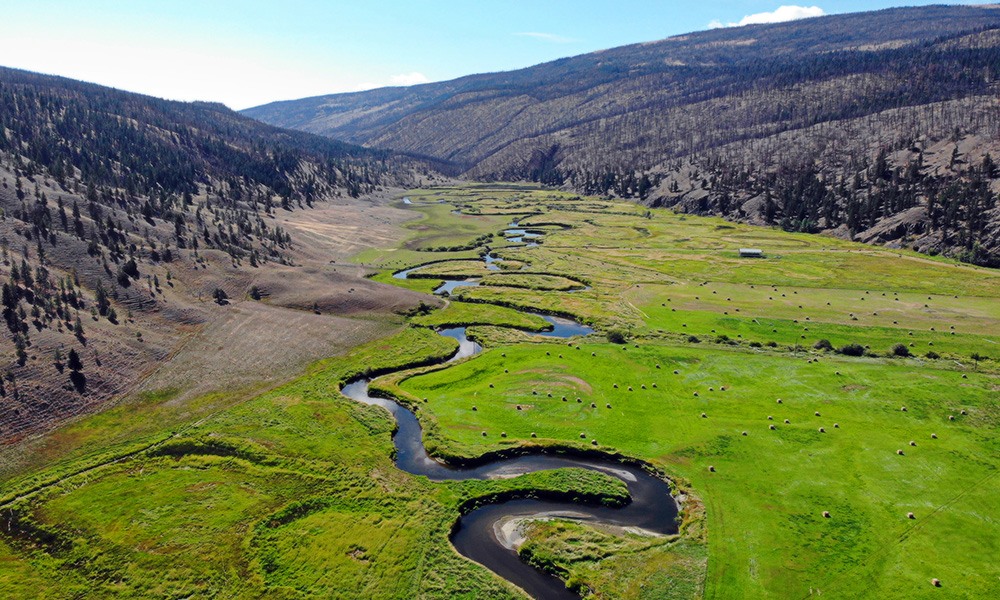
“It generally isn’t until two or three years later that you really start to see what’s happening,” he says. “And what we saw is that the channel expanded and widened in response to the addition of sediment from burnt slopes. And it also accelerated its pace of erosion—the speed at which it erodes banks and moves across the floodplain has accelerated substantially.”
The Bonaparte River has widened up to 130 per cent and the researchers estimate the erosion pace has increased by 230 per cent. People who live nearby, or depend on the river, especially farmers and Indigenous communities such as the Bonaparte First Nation, also noticed a change in spawning beds, an increase of river silt immediately after the fire and that the water was supercharged with sediment.
“We can’t say with certainty how long-lasting this change will be; rather, we expect—and hope—that it will recalibrate with time. But it’s still important for communities and planners to understand that in a five-year timeframe after a wildfire, rivers and floodplains continue to be affected.”
Dr. Ielpi says they cannot predict if this is going to take place at every river touched by a wildfire—as every river and fire are different—but the data they collected allowed them to develop a model to estimate the increase in sediment supply. They were able to document post-fire channel widening and accelerated migration, and provide first-hand evidence of major alterations in landscape dynamics at the watershed scale.
These findings, in turn, have implications for hydraulic engineering and hazard forecasting related to changes in river dynamics downstream of wildfire areas.
The data can also be used for other regions like the Amazon Basin and the Great Basin of the Western United States to help predict potential post-wildfire river movement, floodplain damage, flood threat and even how spawning channels are changing.
“By comparing pre- and post-fire estimates of sedimentation in the Bonaparte River’s watershed, our model ultimately provides evidence of a megafire inducing watershed-wide alterations in stream mobility and geometry,” he adds. “This is an exploratory paper, but I hope it’s one that makes people think about the complex and multifaceted repercussions of wildfires, even years down the road.”
Featured image: An aerial view of the Bonaparte River (Kluhtows to the Shuswap people) floodplain surrounded by burnt slopes. Photo credit: Dr. Alessandro Ielpi.