The Okanagan Basin Water Board (OBWB) held a joint news conference with representatives from the provincial government, Okanagan Nation Alliance, and City of Kelowna to announce significant funding and a unique partnership to help valley communities plan and prepare for future flood events.
The partnership chose Kinsmen Park in Kelowna, the sight of notable flooding last spring, to announce $1.45 million in funding from the National Disaster Mitigation Program and the B.C. Community Emergency Preparedness Fund, to conduct flood mapping and flood risk assessments.
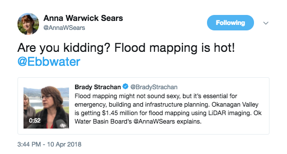
“The weather in the Okanagan is changing,” explained Anna Warwick Sears, OBWB’s Executive Director. “Last spring, we saw historic flooding in our valley, followed by a prolonged dry spell. Climate scientists have warned that extreme fluctuations are going to become more common. This project will help us plan for stronger and safer communities.”
“The amazing thing about this project,” added OBWB chair Tracy Gray, “is the amount of collaboration that has been developed around flood planning our valley, with Okanagan Nation Alliance (ONA) and its member communities, local governments – including the Regional Districts of North Okanagan, Central Okanagan and Okanagan Similkameen, the Town of Armstrong, the cities of Vernon and Kelowna, and the B.C. government. Everyone is working together and all will benefit.”
“The Okanagan Nation affirms our constitutional rights and responsibilities related to our siwɬk (water),” noted ONA Chairman Grand Chief Stewart Phillip. “This announcement comes at a critical point in our shared history when we have the culmination of multiple challenges, including those posed by climate change, that threaten the health and function of siwɬk systems in the Okanagan. We must step away from old approaches and practices and come together in partnership to commit to the sustainability of siwɬk and the safety of everyone who inhabits Syilx territory.”
According to Sears, the flood mapping will use LiDAR (Light Detection and Ranging), a radar technology that is a form of aerial imaging. LiDAR creates a digital 3D map of the landscape, to help with flood mapping and flood response planning and disaster mitigation. It is combined with geo-referenced aerial photos to accurately map the landscape.
“The LiDAR will show where water is likely to flow. It will include modeling of how much water can be expected and help determine vulnerable locations,” she explained. And thanks to funding from Emergency Management B.C. to OBWB to acquire the LiDAR and aerial photos, and with GeoBC (a branch of B.C. Ministry of Forests, Lands and Natural Resource Operations and Rural Development) providing the project management and data management, all of this data will be made completely available at no-cost to Okanagan communities.
“This data will be critical in providing up-to-date information to planners and decision-makers in local government and First Nations communities, as well as the province, about where communities should and should not be building, and where mitigation plans are necessary in already developed areas,” Sears added.
After spending several weeks last spring in the RDCO’s Emergency Operations Centre to deal with flooding, Brian Reardon, the regional district’s Chief Administrative Officer and Emergency Program Director is pleased to see this project move ahead. “The LiDAR work is a big boost for our ongoing Central Okanagan Floodplain Mapping project and will provide vital information as we move forward with modeling floodplain maps across our region.”
“Being prepared and planning ahead is paramount to protecting public safety and ensuring the economic health of B.C. communities,” said Mike Farnworth, B.C. Minister of Public Safety and Solicitor General. “We know that flooding is a very real concern for Okanagan communities. This investment will give the Okanagan Water Basin Board the support they need to help protect Okanagan communities and the people who live there.”
In addition to the $1.45 million, the OBWB would like to acknowledge an additional $600,000 in flood mapping funds from the B.C. Community Emergency Preparedness Fund, administered by the Union of BC Municipalities. This was provided to Okanagan communities in December 2017. Also, the Government of Canada’s National Disaster Mitigation Fund is currently reviewing almost $2 million in additional funding applications for flood mapping and flood risk assessments to Okanagan local governments and the ONA. We hope to hear about the success of these applications in May. These funds will be used to integrate the LiDAR data into floodplain maps and further develop flood risk assessments.
The next issue (May/June) of Water Canada will focus on climate change adaptation, with feature content on national efforts to managing flood risk.