Last week, Greenland International Consulting Ltd. completed the next iteration of the Healthy River Ecosystem AssessmenT System (THREATS), a data management tool for watershed planning.
The development of the company’s internet-based open data and open source GIS platform began less than year ago. Inspired by research funded by the Canadian Water Network and prototype development led by Dr. Monique Dubé, Greenland Consulting secured source code rights and began further developing the platform. The company has thanked the Government of Canada and the National Research Council of Canada Industrial Research Assistance Program (NRC – IRAP) for support in developing the latest version of THREATS.
The latest platform includes a cumulative effects assessment focus and can be used to develop related policies and management frameworks. THREATS can also serve as a cost-effective tool for watershed planning, by assessing, predicting, and managing the cumulative effects of multiple stressors affecting the quality and quantity of our surface waters.
THREATS can be customized to include new monitoring databases and address specific client or geographic needs whether for Indigenous communities, government agencies, or resource industries. Further development phases will be initiated soon for export to the global market opportunities and linking western-science with Indigenous knowledge to assess the cumulative effects of the technology.
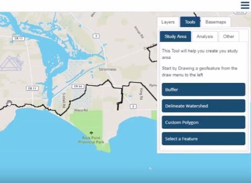
This demonstration video samples the application of THREATS in Alberta and Ontario.
The video introduces just a few of many possible applications that can access the real-time and open data provided by THREATS, as well as an extensive Canada-wide library of climate and watershed databases with science-based modeling functions.
The THREATS platform, now operational for use in Ontario and Alberta, includes:
- A state-of-the-art database architecture designed to efficiently store and retrieve monitoring data from multiple monitoring stations, sampling events, and contributing parties;
- Advanced statistical trends analysis;
- Dynamic updating of a user’s analyses as new data is added;
- Web accessibility for searching, plotting, mapping, preparing reports, and adding data with a dashboard interface for managing and responding to environmental trends; and
- Real-time ability to support a tier transition or triggers exceedance management approach, while also being able to support proactive risk mitigation practices and procedures.


