Oak Hammock Marsh, MB – The 15 species of waterfowl known as sea ducks constitute more than a third of the duck species breeding in North America, yet they are the most poorly understood group of waterfowl. Filling this knowledge gap was the impetus behind a new cross-border effort that’s putting sea duck conservation on the map—and shedding light on how we can help protect important habitat for these birds.
The Sea Duck Key Habitat Sites Atlas was created by a team of conservation researchers from across North America. Using the best available science and strict criteria, they identified the most important areas, at a continental scale, for birds that frequent the coasts as well as areas of the boreal forest and Arctic tundra. This information is key to understanding why these sites are important and how we can best protect them for sea ducks and other wildlife.
The sea duck atlas is an initiative of the Sea Duck Joint Venture, a partnership under the North American Waterfowl Management Plan. Ducks Unlimited Canada (DUC) research biologist Nic McLellan played a lead role in the creation of the atlas.
“By knowing which areas are most important to sea ducks, we can incorporate this knowledge into future conservation planning,” says McLellan. “It will also be very useful in helping to avoid environmental impacts and evaluate environmental assessments.”
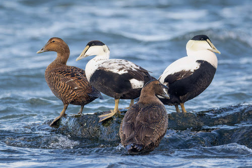
Sea ducks that frequent North America include eiders, scoters, mergansers, goldeneyes as well as buffleheads, long-tailed ducks and harlequin ducks. They are an important subsistence food for northern communities and are becoming more popular among hunters. Sea ducks are also among the most ornately coloured of waterfowl, making them a favourite among photographers and birdwatchers.
The sea duck atlas identified 85 sites as providing critical habitat for these birds, many of which are in Canada. McLellan says, “The majority of North American sea ducks breed in Canada and many stage or winter along our coasts, including the Great Lakes. We know that having healthy habitats is critical for population success. Today, coastal development, environmental risks such as oil spills and the impacts of climate change are posing significant threats to these habitats.”
Here’s a look at some key landscapes where DUC is actively working to support sea duck populations through innovative science and on-the-ground conservation:
- Atlantic Canada: DUC is working throughout the region to support the conservation of common eiders, which builds on research and conservation efforts that have been underway in Newfoundland for 30 years. Today, DUC is partnering on a large, innovative telemetry study where female birds are tagged across the breeding range, and their movements tracked. Data from the study will shed light on breeding success, potential linkages between key sites identified in the sea duck atlas as well as finer detail on habitat use.
Many important wintering areas for common eider exist along the coast of Newfoundland. For example, more than 37,000 common eider winter between Quirpon Island and Grey Islands. - Great Lakes: DUC’s coastal wetland restoration work supports sea ducks with migration stopovers for rest and feeding, and enhanced water quality across watersheds. DUC also operates an invasive species program to remove and monitor European water chestnut, which chokes out native vegetation and damages the ecological health of sea duck habitats.
The sea duck atlas recognizes Eastern Lake Erie, which is important for spring and fall staging and wintering for a diversity of sea duck species. It’s particularly important in the fall for bufflehead, long-tailed duck, common goldeneye, and red-breasted and common merganser. - Quebec: Some of the key sites identified in the sea duck atlas support a significant proportion of at-risk species. For example, the Baie des Rochers site along the St. Lawrence River—which is only two square kilometres in size—supports 10 per cent of the Barrow’s goldeneye wintering in the Eastern population. DUC has a long history of delivering conservation and restoration projects along the St. Lawrence and, with the support of the Québec Ministry of the Environment and many other partners, has mapped more than 90 per cent of the St. Lawrence Lowlands to identify the location, class and type of wetlands in the region.
- British Columbia: The Fraser River Estuary is home to a high density of sea ducks. It is the largest estuary in the province and part of the Salish Sea Key Site identified in the sea duck atlas. DUC is engaged in multi-million-dollar conservation projects in the Fraser Estuary to restore coastal habitats that connect the river to the sea. By breaching dikes, modifying water controls, battling invasive species and delivering other conservation work, DUC is helping combat the many threats facing Canada’s most important overwintering area for waterfowl.
“Waterfowl are often held up as a conservation success story, with populations rising by approximately 150 per cent since the 1970s,” says McLellan. “Sea ducks, however, are an exception. We must apply the same conservation effort and attention to these species to ensure they, too, will thrive. The creation of the sea duck atlas is a significant first step in this direction.”
The Sea Duck Key Habitat Sites Atlas is available for download and will be a valuable tool for other habitat Joint Ventures, marine and land-use planners, Indigenous groups, developers, environmental consultants, natural resource agencies, wildlife conservation groups and other stakeholders.

