Foundry Spatial was recognized in the Water Resources category of the 2021 Water’s Next Awards.
The team at Foundry Spatial Ltd. is hoping that with easier access to critical water-related data and reporting, a better balance can be struck between social, economic, and environmental needs. Scientific information on water supply and demand is often difficult to find, acquire, and understand. These challenges have an impact on decision-making and the outcomes are immediately visible in the world around us.
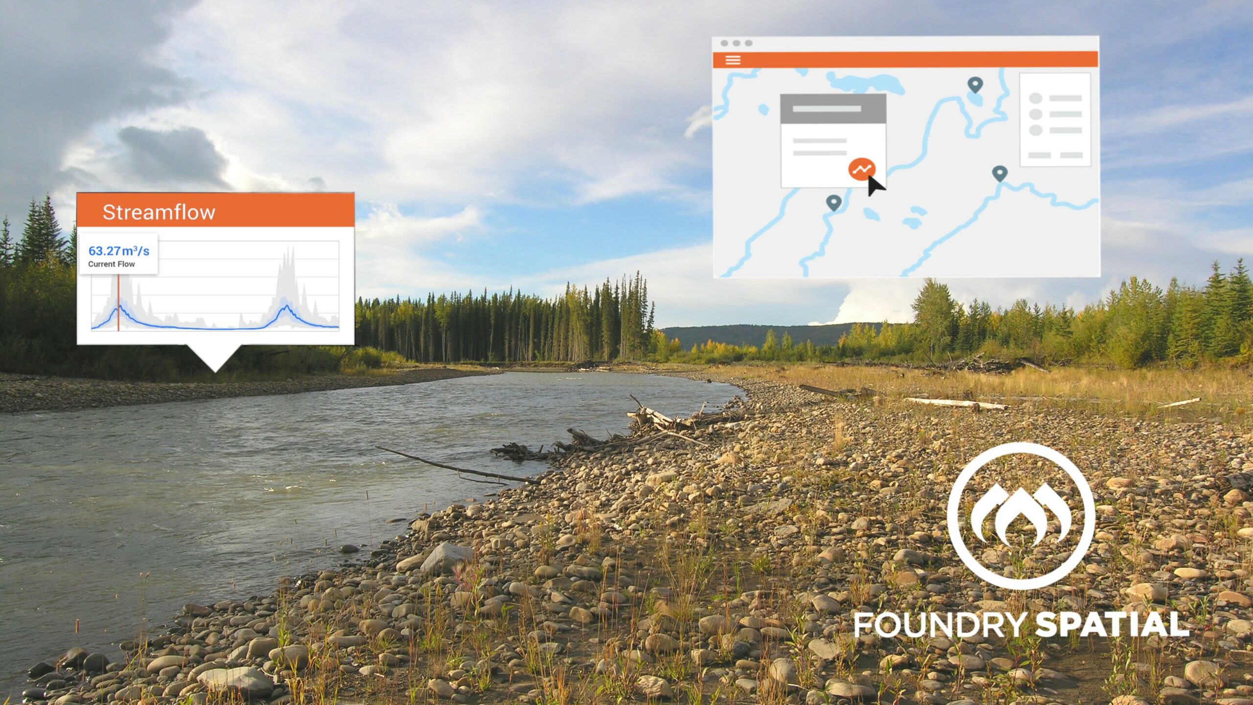
In response to issues such as water scarcity, degraded water quality, aquifer depletion, or saltwater intrusion, Foundry Spatial has developed the Water Framework. The Water Framework takes massive volumes of real-time and historic environmental monitoring data, specialized hydrology models and analytical routines, and delivers easy to digest insights.
According to Ben Kerr, founder and CEO, the first version of the Water Framework was developed to support Foundry Spatial’s own internal needs. The company was hired as consultants to deliver large regional water resource evaluations that required gathering, processing, and analyzing water data from hundreds of monitoring locations.
Foundry Spatial’s leadership team was faced with a choice—hire a team of junior environmental scientists to analyze the data manually, or hire software developers instead to automate the analysis and reporting in hopes of future efficiency. They chose the latter, shared the first version with a willing client, and haven’t looked back since. Ongoing development is now driven by a combination of client demands and the incorporation of new analytical capabilities such as streamflow depletion from groundwater pumping and cumulative impacts of forest disturbance.
“Technology is an enabler, but shouldn’t be the only focus of a project” says Kerr. “Fundamentally, ensuring high quality data, as well as understanding and successfully meeting user needs must always be top of mind.”
With critical attention spent on optimizing the user experience, the framework provides accurate, reliable, and relevant information for any specific location of interest. In a matter of minutes, users can retrieve knowledge that would otherwise require costly consultants weeks, or even months, to produce.
Foundry Spatial’s goal is to enable users from governments, Indigenous communities, and industry to make more informed decisions about watersheds and aquifers, and to better understand the impact decisions have on the local environment. The company has had implementations continuously running in Western Canada since 2014. The team is now entering a commercial push to roll out the technology into new jurisdictions, anticipating new projects in two US states by the end of 2021.
The biggest reward for the Foundry Spatial team has been hearing from users who’ve become better informed with the help of their powerful tool, and were able to take immediate action to resolve that problem. As Kerr reflects, “Poor water management can cause massive impacts. Helping clients to avoid these risks is core to the value proposition of our project.”
Foundry Spatial seems poised to support balanced, resilient water management decision-making, ensuring that nature, industry, and communities can continue to prosper and adapt to our changing climate.
This profile was written by Evan Pilkington, a seriously water-obsessed freelance writer, for the July/August 2021 issue of Water Canada. The credit for the header image goes to Foundry Spatial.
The nomination period for the 2022 Water’s Next Awards is now open! Learn more about the awards here.