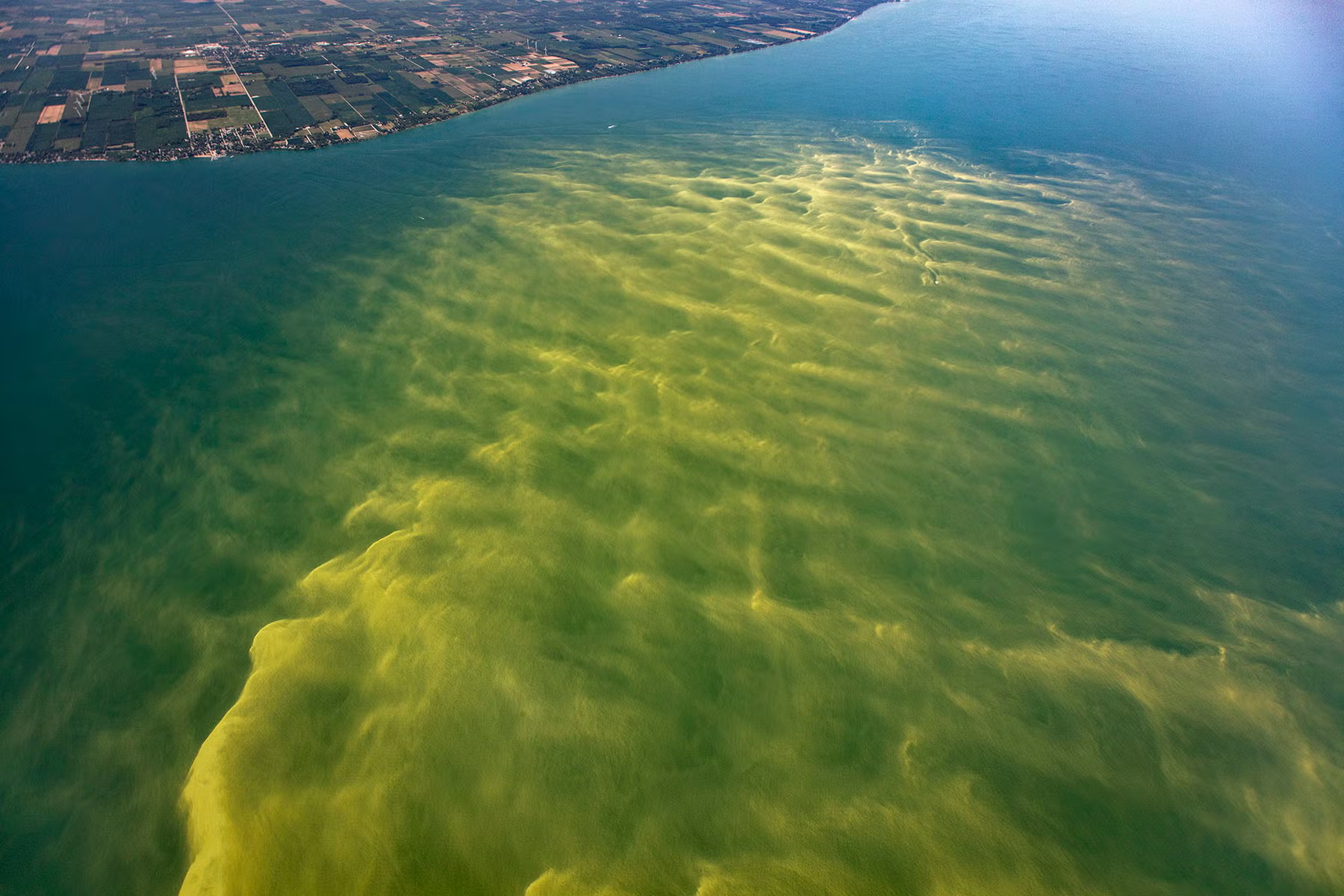
A new study from the University of Waterloo suggests shoreline erosion is a far more significant source of phosphorus to Lake Erie than previously understood, potentially undermining expected gains from watershed management efforts.
Researchers developed a mass balance model showing that erosion of coastal bluffs along Lake Erie’s central and eastern basins contributes substantial phosphorus to nearshore littoral zones — the shallow areas where land meets water. Those zones act as a major pathway for eastward transport, with roughly 40 per cent of phosphorus entering Lake Erie ultimately flowing into Lake Ontario through the Niagara River.
“Our research shows that what happens along the shorelines of Lake Erie affects not only Lake Erie itself but also downstream Lake Ontario,” said co-author Serghei Bocaniov, a research associate in the university’s Ecohydrology Research Group. “Coastal erosion generates around 15 per cent of the total phosphorus input to Lake Erie. If we focus only on what flows in from the watershed, we overlook a major part of the story.”
Phosphorus is essential for aquatic ecosystems, but excessive levels can fuel harmful algal blooms that threaten drinking water, recreation, and ecological health. While governments and scientists have spent decades working to reduce phosphorus entering the lake from rivers and streams, the new research highlights that shoreline erosion and lake circulation patterns must be factored into management decisions and climate change projections.
The study identifies several key findings:
- Erosion of coastal bluffs—especially in the central basin—is a large, previously overlooked phosphorus source.
- Nearshore transport parallel to the coastline moves phosphorus toward the Niagara River and Lake Ontario.
- Lake circulation patterns influence how phosphorus shifts between nearshore and offshore waters.
- Climate warming may worsen nearshore algal blooms by weakening the transfer of phosphorus to offshore zones.
These results challenge long-held assumptions about how phosphorus enters and moves through Lake Erie, the researchers said. They also indicate that other pollutants, including pesticides and microplastics, may travel along similar pathways, bypassing sediment burial and moving toward Lake Ontario.
The model, which uses data from 2003 to 2016, provides the first detailed picture of how Lake Erie’s nearshore zones influence phosphorus cycling. The team says the simple, adaptable framework can help predict how phosphorus levels will respond to changes in watershed inputs, erosion, and circulation patterns—offering scientists and policymakers a new tool to protect both Lake Erie and Lake Ontario.
“This work expands our understanding of how the limiting nutrient phosphorus enters and moves through large lake ecosystems,” said Philippe Van Cappellen, professor and Canada Excellence Research Chair Laureate in Ecohydrology. “By recognizing the pivotal role of littoral dynamics, we can more realistically predict how nutrients and pollutants impact our shared Great Lakes.”
The study, Mass balance modeling highlights the role of the littoral zone in modulating the cycling of phosphorus in a large, multi-basin lake (Lake Erie), appears in the Journal of Great Lakes Research.
Featured image: Aerial Associates Photography, Inc. by Zachary Haslick / NOAA Great Lakes Environmental Research Laboratory